Smart Inspectors
A Joint German-Dutch Research Project on UAV-based Remote Sensing
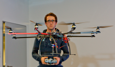
A local farmer takes a drive out to a crop field, opens the boot of his truck and starts up a GPS-guided UAV – an unmanned aerial vehicle, commonly referred to as a ‘drone’ – that can be controlled via his smartphone. He’s not using an ordinary drone, however; this one is outfitted with advanced IR cameras and data processing systems. As the drone traverses the field, captured images are instantaneously processed and wirelessly relayed to the farmer’s smartphone, where he now has a bird’s eye map of the field and can see which areas of crops need the most attention at the moment. Theoretical sci-fi scenario? Not at Rhine-Waal University of Applied Sciences. Together with local German and Dutch partners from industry and research, we’re actively developing these kinds of advanced solutions in our “Smart Inspectors” project. The project is dedicated to developing innovations along the entire process chain of UAV-based remote sensing, from special infrared cameras and radar technology, to UAVs and drones, to wireless data transmission and methods of data analysis and depiction.
Prof. Dr.-Ing. Rolf Becker of Rhine-Waal University of Applied Sciences was primarily responsible for initiating Smart Inspectors via an application to Euregio Rhine-Waal, which contributed invaluable strategic funding advice towards the successful realisation of the project. As lead partner of the project, Rhine-Waal University of Applied Sciences is actively represented by contributing professors and members of our research staff. Together with an interdisciplinary team of colleagues from the Wageningen University and Research Centre (remote sensing), the agricultural research centre Haus Riswick, sceme.de GmbH (sensors), IMST GmbH (radar) and BLGG Research (agricultural research and consulting), the project’s research team is currently developing a range of new innovations in processes and applications for infrared and radar remote sensing.
The new IR/radar remote sensing system is designed to be carried by drones and other small ultra-light aircraft. The system is more cost-effective and flexible to deploy than conventional airborne remote sensing systems, and it’s also less affected by cloud cover than observational satellites.
Potential applications for this new remote sensing system can be found in a variety of other sectors, as well. It could be extremely useful, for example, in traffic observation, technical inspections of industrial complexes, flood prevention (e.g. monitoring dikes and dams for breaks), or non-intrusive monitoring of nature preserves and animal populations.
Additionally, by establishing a transnational network of experts in the field of remote sensing, the project also ensures the future use and demand of remote sensing systems and processes in the region. Working together with network partners, companies in the Lower Rhine region now have the opportunity to collaborate on developing new uses for remote sensing products and services in a variety of sectors, for example emergency services, technical monitoring, environmental protection or agriculture, thus generating new jobs for the region as a result. With this new high tech offensive in Euregio Rhine-Waal, new market segments can be occupied and newly developed technologies can penetrate the global market and reach those who can benefit the most from the, such as countries which rely on large-scale industrial farming.
Project partners are Rhine-Waal University of Applied Sciences (Kleve and Kamp-Lintfort), Wageningen University (Wageningen), BLGG Research (Wageningen), sceme.de GmbH (Kalkar), the agricultural research centre Haus Riswick (Kleve) and IMST GmbH (Kamp-Lintfort).
Associated partners are ISIS-IC GmbH (Wesel), Alterra (Wageningen), TerraSphere Imaging & GIS B.V. (Amsterdam), CARRIER³ Goran Kelemen (Emmerich), and ‘Flieg mit uns’(Borken/Wesel).
With funding from the European INTERREG IV A-Programme “Deutschland-Nederland”
With additional support from:

![]()


![]()
Project Lead
Prof. Dr.-Ing. Rolf Becker
rolf.becker@hochschule-rhein-waal.de
Project Partners
BLGG AgroXpertus
BLGG Research
IMST GmbH
Landwirtschaftszentrum
Haus Riswick
sceme.de GmbH
Wageningen UR
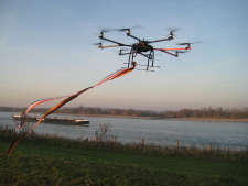
The ‘octocopter’ flying along the Rhine (Beate Becker)